Mt. Hood Trail Games
Course Information
September 7, 2024
The Course!
The Trail Games course involves runners completing three different loops high up on Mt. Hood: Lupine Loop, Beargrass Loop and Umbrella Loop. Each loop starts and finishes on the Sun Deck at Mt. Hood Meadows lodge, with each loop starting in a similar direction and all returning from a similar direction. Each loop offers magnificent views, unique character and adventure, plus they’re each 99% super runnable singletrack trail!
Loop Details
LUPINE LOOP: 4.8 miles / 900’ of ascent / 900’ of descent. This loop appears blue and travels counterclockwise on the map.
BEARGRASS LOOP: 4.9 miles / 800’ of ascent / 800’ of descent. This loop appears yellow and travels clockwise on the map.
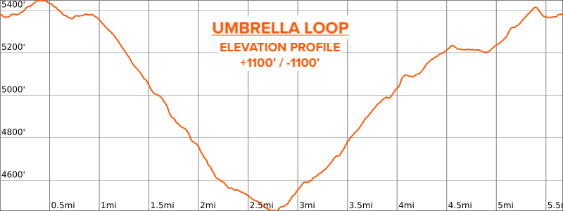
UMBRELLA LOOP: 5.8 miles / 1100’ of ascent / 1100’ of descent. This loop appears orange and travels clockwise on the map.
TOTAL: 15.5 miles / 2,800’ of ascent / 2800’ of descent.
Course Map
INTERACTIVE MAP: Click “Open in Caltopo” on the upper left of the course map image for a full window of the map, where you can change layers, zoom in and out, etc.
GPX DATA: Click HERE for a .gpx data file of the course for use and reference on your favorite GPS watch or navigation app on your smartphone.
Aid Station & Transition Zone
An aid station will be set up on the Sun Deck at Mt. Hood Meadows at the start/finish of each loop, doubling as a transition zone and relay exchange area. The aid station offers water, Gnarly Nutrition Fuel2O energy drink, soda, Spring Energy gels and other tasty offerings. Bring your own cup for drinking :)
All Daybreak races are cupless, so be sure to bring your own refillable cup or bottle for filling up liquids at the aid station. Staying properly hydrated during the race is essential, so please plan to bring your own hydration equipment with you on course (hydration pack, belt, handheld bottle are all great options), and plan to utilize the aid station to top off your fluids.
Course Loop Descriptions & Elevation:
Lupine Loop:
This section is 4.8 miles long, with the first 2.25 miles a rolling climb up to the Timberline Trail, then 1.25 miles of rolling descent with several small stream crossings. The final 1.25 miles is a sweet descent onto Umbrella Falls Trail, then a LEFT turn for a short stretch back to the Mt. Hood Meadows Lodge where the loop began.
Beargrass Loop:
This section is 4.9 miles long, with the first 1.5 miles a rolling, then steady climb on the Beargrass Trail through mixed forest and open meadows. Then a sweet descent rewards runners for 2 miles along the rim of Clark Canyon, followed by half a mile of flat trail through more intermittent meadows and forest before passing Umbrella Falls, one of the larger and more charming waterfalls on Mt. Hood. The last mile has a rolling climb on Umbrella Falls Trail before turning RIGHT for the final short stretch back to the Mt. Hood Meadows Lodge where the loop began.
Umbrella Loop:
This section is 5.8 miles long and is the most difficult of the three loops! It also heats up the earliest if we get a warm day, being the lowest elevation route. Sweeping views await along the first half of this loop, with views out to the Central Oregon high desert, Mt. Jefferson and the Pacific Crest. The first mile is gently rolling, followed by an amazing 1000’ descent over the next 2 miles down to Elk Meadows. The next 1.5 miles are a steady march up along the rim of the Hood River back up to Umbrella Falls. From there, it’s a rolling, gentle climb for half a mile, then the last short stretch back to Mt. Hood Meadows where the loop began.
Cancellations
See the Daybreak Racing Cancellation Policy.
This event is located on the Mt. Hood National Forest. In accordance with Federal law and U.S. Department of Agriculture policy, this institution is prohibited from discriminating on the basis of race, color, national origin, sex, age or disability. USDA is an equal opportunity provider and employer.


