
Siuslaw Dunes 50K
March 16, 2024

50K
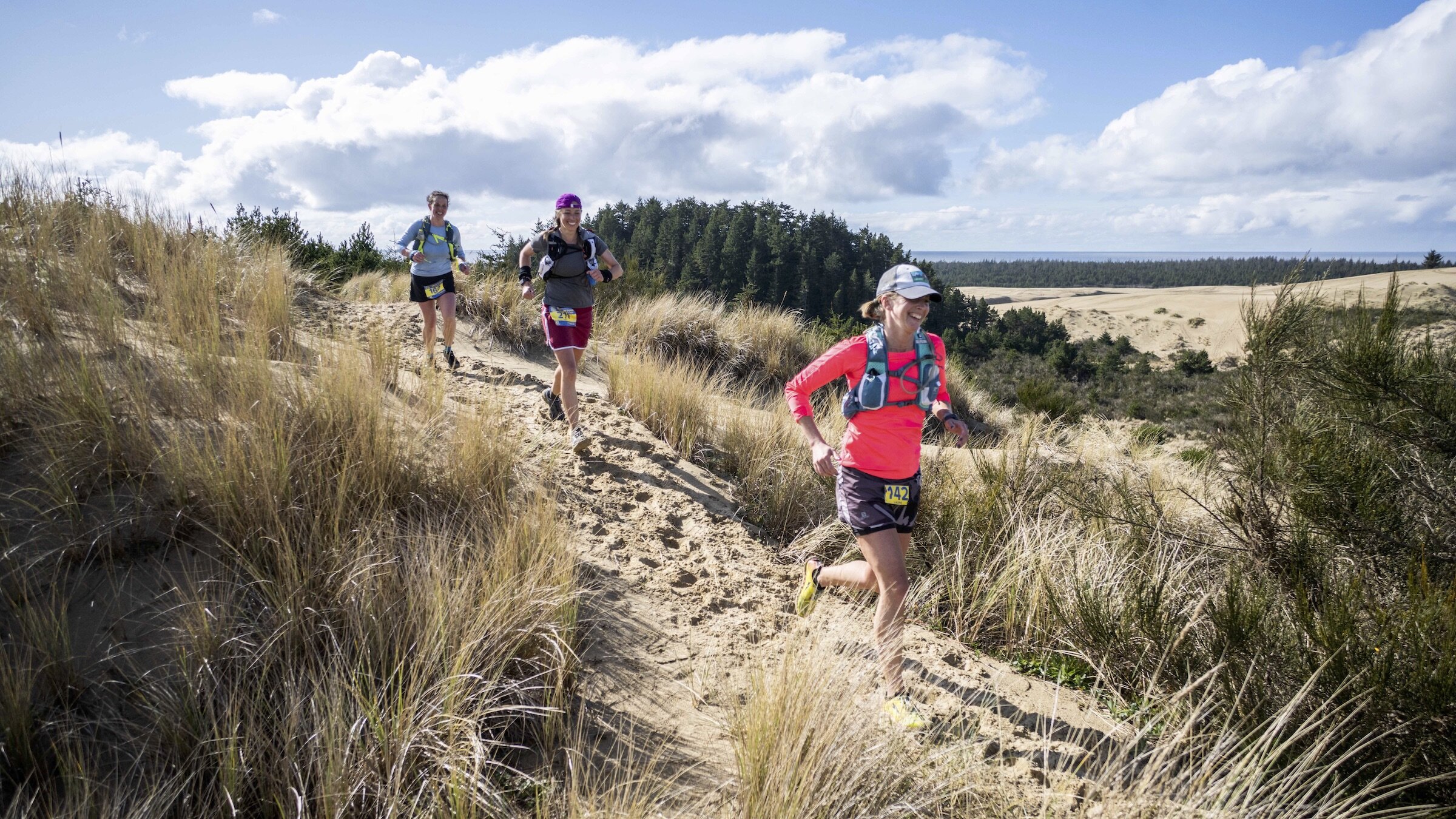
This is an incredibly diverse, challenging, mostly point-to-point course and there is nothing else like it anywhere, so bring your sense of adventure to the coast and LET’S DUNE THIS! The Siuslaw Dunes 50K course (31.0 miles) offers magnificent views on a mostly point-to-point style course along the famous Oregon Dunes, magnificent forested single track trails and remote ocean beaches.
Runners travel through an assortment of ecological zones, including lush old growth coastal rainforest, vast open sand dunes, riverside estuaries, freshwater lakes, as well as a fascinating transition zone between the dunes and the ocean called the deflation plain, which teems with water-loving plants and animals, especially amphibians and migratory birds.
Race Day Schedule
SATURDAY, MARCH 16, 2024
Bib Pickup & Check-In: 5:30AM-6:15AM at East Woahink Day-Use Gazebo. (Bring a headlamp)
Shuttle Pick Up: Load up at 6:15AM; Bus departs by 6:30AM (Bring a headlamp)
Shuttle Drop Off: 6:45AM at Waxmyrtle Campground
Start Time: 7:00AM (Bring a headlamp)
Finish Line Cut-Off: 4:00PM (9 hours)
On Course Cutoffs:
11:15AM at Tahkenitch Creek Aid Station #2 - mile 15.5
1:00PM at Waxmyrtle Aid Station #3 - mile 21.4
3:00PM at Cleawox Aid Station #4 - mile 27.1
Course Map
MAP: Click on the course map image to open a high resolution copy.
INTERACTIVE MAP: Click HERE for an interactive course map in Caltopo.
GPX DATA: Click HERE for a .gpx data file of course.
Elevation Change
The course includes approximately 2,100' of ascent along with 2,070' of descent. Most of the elevation gain is seen during the forested loop portion midway between Aid Station 1 and 2, but the rolling nature of the opens dunes section between Aid Station 3 and 4 will take its toll.
Course Surfaces
Terrain types alternate continuously throughout the race, presenting a unique challenge that will demand a runner’s attention and fitness. For example, over a given 5 mile stretch, a runner could see a mile of beach, then a mile of sandy trail, cross a patch of open dunes, then enter 2 miles of forested singletrack trail, and so on. The sand dune sections are more firm after consistent rains, and more loose following extended dry weather and/or windy conditions.
Overall, the 50K consists of the following surface types and approximate mileage totals by surface type:
13.3 miles of intermittent sandy trail in rolling shore pine forest (some firm/packed surface in forest, some loose sections where unforested/exposed)
11.0 miles of intermittent forested dirt single track (classic dirt trail with some roots and rocks)
1.4 miles of ocean beach, split into two 0.70 mile segments (mostly firm wet sand, very flat)
4.3 miles of open dunes in one main 4 mile segment and another .3 mile segment (flat areas and descents are pretty runnable, climbs are soft and brutal!)
1.0 miles of intermittent hard surface park paths and forest road shoulder
Aid Stations
There are four aid stations staffed with enthusiastic volunteers offering tasty fuel: Gnarly Nutrition Fuel2O energy drink, water, soda, Spring Energy gels, bananas, oranges, chips, PB&J sandwiches, and more. All Daybreak races are cupless, so be sure to bring your own cup for liquid at aid stations.
| Aid Station | Total Distance (mi) | To Next Aid (mi) | Toilet | Crew | Drop Bags | Cutoff |
|---|---|---|---|---|---|---|
| Start - Waxmyrtle Campground | 0 | 6.6 | Yes | Yes | -- | -- |
| #1 - Tahkenitch Creek | 6.6 | 8.9 | Yes | Yes | Yes | -- |
| #2 - Tahkenitch Creek | 15.5 | 5.9 | Yes | Yes | Yes | 11:15AM |
| #3 - Waxmyrtle | 21.4 | 5.7 | Yes | Yes | Yes | 1:00PM |
| #4 - Cleawox Lake | 27.1 | 3.9 | Yes | Yes | No | 3:00PM |
| Finish - Honeyman State Park - East Woahink | 31.0 | -- | Yes | Yes | -- | 4:00PM |
Crew
Crew are welcome at all aid stations and the Finish area but NOT at the Start Line.
Crew Access at Aid Stations:
Tahkenitch Creek: Park at the Tahkenitch Creek Trailhead. Display your NW Forest Pass or daily parking pass on your vehicle. NO CELL SERVICE available.
Waxmyrtle: Parking at Stagecoach Trailhead, a short walk from the aid station. There is a Forest Service day use fee (or display your NW Forest Pass). Limited cell service available.
Cleawox: Parking is at the Sand Dunes Day Use parking area at Honeyman State Park. There is a $5 parking fee upon entrance to the parking area. Cell service is fair here.
Drop Bags
If you don’t have crew supporting you, you may have a drop bag available at Tahkenitch Creek and Waxmyrtle. There will be a location at morning check-in to place your Tahkenitch Creek dropbags. Bring Waxmyrtle drop bags with you to the race start line. Please ensure your bag meets these rules:
SIZE: One drop bag per runner. Bag size must be smaller than a 20L daypack, water resistant and made of durable material. Bags that are too large will not be accepted and will not go the aid station.
LABEL: Arrive to the race with a PRE-MADE label adhered/attached to your drop bag that includes your first name, last name and bib number in large bold permanent writing.
RETURN: Drop bags will be returned back to the Start/Finish once the aid station shuts down after race sweepers arrive. Have your crew grab your drop bag if available. Please be sure to pick up your drop bags after you finish.
CONTENTS: Do not store valuables in drop bags! The race is not responsible for missing, damaged, lost or stolen drop bags or contents.
FORGOTTEN BAGS: Please note we do not ship or deliver forgotten drop bags. You can arrange to pick up forgotten drop bags from us if we have them.

Pacers
The event permit does not allow pacers.
Course Detail By Section:
Start (Waxmyrtle Trailhead) to Aid Station 1 (Tahkenitch Creek): Runners depart Waxmyrtle Campground starting area for a quick half mile loop around the Lagoon Trail to spread out, then runners head out along a beautiful, rolling riverside estuary dirt singletrack trail that transitions to packed sand trail for 1 mile that ends at the beach. Runners head south along this .70 mile section of remote ocean beach, which feels almost like a wilderness area, full of great blue herons, sandpipers, raptors and gulls, with very few signs of human presence.
***BEACH SAFETY***
Always keep an eye on the ocean and NEVER turn your back on the water so you won’t be caught off guard if a bigger wave surges up the beach. These “sneaker waves” are unpredictable, powerful and can easily knock adults off their feet.
Stay away from logs on the beach or in the surf. The logs absorb water like sponges, increasing their weight by up to several tons. The ocean is strong enough to pick up even the heaviest log and roll it over you.
The course exits the beach at the Carter Dunes Trail, a relatively flat meandering path through some lovely shore pine, salal and wax myrtle forest on sandy trail for approximately .75 mile, then a RIGHT turn onto a couple mile section of rolling open dunes toward Oregon Dunes Loop Trail. On Oregon Dunes Loop Trail, runners continue south across a mix of dunes and shore pine lined sandy trail for 1.3 miles, serenaded by frogs, various birds and other wildlife, as well as the ocean’s ever-present rumble nearby. At this point, runners reach the Tahkenitch Creek ford, which is a 30-40’ wide crossing that is typically 1’ to 2’ deep, a very slow, gentle current and sandy bottom as it meanders to the ocean. There will be an experienced team of volunteers to help ferry runners across the creek on SUP’s, or the option to wade the crossing point. The course picks up on the other side of the creek, for some super sweet rolling dirt singletrack for a quarter mile, then veer LEFT at a junction for a short quarter mile out n back segment to Tahkenitch Creek Aid Station. Vault toilet on site.
Aid Station 1 (Tahkenitch Creek) to Aid Station 2 (Tahkenitch Creek): Departing Tahkenitch Creek Aid Station on the short quarter mile out n back trail, veer LEFT at the junction and continue 1.5 miles on fantastic mixed rolling dirt and sandy singletrack along Tahkenitch Creek Trail to a junction where the loop portion of the course begins. Runners turn LEFT at the junction to begin the loop, traveling inland across sandy trail for half a mile and a brief area of open dunes before entering deep, old forest for another half mile, then veer RIGHT at a trail junction to continue the loop, now on Three Mile Lake Trail for 3 miles of hilly, supremely blissful mature forest singletrack with several incredible pocket views of the coastline. As the course exits the forest for more sandy shore pine trail sections, the route turns north following a very challenging rolling dune trail segment back to the junction that completes the loop portion. Veer LEFT at the junction, now back on Tahkenitch Creek Trail for 1.5 miles, then veer RIGHT for the quarter mile out n back for Tahkenitch Creek Aid Station 2. Vault toilet on site.
Aid Station 2 (Tahkenitch Creek) to Aid Station 3 (Waxmyrtle Campground): Departing Tahkenitch Creek Aid Station for the second time, runners return the way they came, veering RIGHT and on trail back to the Tahkenitch Creek ferry crossing once again, then north across the sandy Oregon Dunes Loop Trail, then back out to the beach via Carter Dunes Trail (Don’t forget the Beach Safety tips!!!), then up the beach 2.2 miles to Waxmyrtle Trail, then along Waxmyrtle Trail to Waxmyrtle Aid Station. Portable toilets and crew access on site.
Aid Station 3 (Waxmyrtle Campground) to Aid Station 4 (Cleawox Lake): Runners depart the Waxmyrtle Aid Station, cross the paved road for the Lagoon Trail skirting Lagoon Campground, then a short segment of paved forest road enter the hilly forested sandy trail at Incinerator Trailhead. Follow the sandy trail for 3/4 mile, passing a cool viewpoint above Siltcoos River along the way, before entering the main 4 mile open dunes section of the course. Runners follow a northerly route following our course markings across the open dunes and are immediately greeted with spectacular, sweeping views of the famous Oregon Dunes. The course follows a series of wooden Forest Service sign posts, indicating the boundary between non-motorized use and motorized use across the big dunes. Please keep these sign posts on your left, so you remain in the non-motorized area. Use an efficient running stride on the sand dunes so you aren’t wasting precious energy pushing off. After 4 miles on the dunes, you’ll see Cleawox Lake, and know you’ve completed all the sandy sections of the race! The course then descends down the last dune to Sand Dunes Day-Use parking area next to Cleawox Lake at Honeyman State Park. Park bathrooms and crew access on site.
Aid Station 4 (Cleawox Lake) to Finish (East Woahink Day Use at Honeyman State Park): Departing Cleawox Aid Station, veer right to skirt the parking lot and enter a groomed park trail that crosses the Honeyman State Park campground road, then onto a bike path bridge over Highway 101. Shortly after the highway crossing, runners veer RIGHT onto a sweet 1.8 mile dirt singletrack lollipop segment above the shoreline of Woahink Lake. After completing the lollipop segment, veer RIGHT back onto the bike path, traveling on a mix of groomed park path and dirt singletrack for half a mile before exiting onto the maintained park lawn peninsula of East Woahink Day Use Area. Follow the course flagging to skirt the perimeter of the park peninsula for the final half mile to the finish line at East Woahink gazebo, where we’ll be cheering with your friends and families!
Cancellations
See the Daybreak Racing Cancellation Policy.
This event is granted by a Special Use Permit through the Siuslaw National Forest, U.S. Forest Service and Oregon State Parks. In accordance with State and Federal law and U.S. Department of Agriculture policy, this institution is prohibited from discriminating on the basis of race, color, national origin, sex, age or disability. The State of Oregon and USDA are equal opportunity providers and employers.